


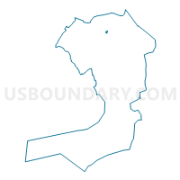
Voting District 2200002, Queens County, New York
About
Outline

Summary
| Unique Area Identifier | 634431 |
| Name | Voting District 2200002 |
| County | Queens County |
| State | New York |
| Area (square miles) | 0.05 |
| Land Area (square miles) | 0.05 |
| Water Area (square miles) | 0.00 |
| % of Land Area | 100.00 |
| % of Water Area | 0.00 |
| Latitude of the Internal Point | 40.76752290 |
| Longtitude of the Internal Point | -73.82877770 |
Maps

Graphs
Select a template below for downloading or customizing gragh for Voting District 2200002, Queens County, New York


Neighbors
Neighoring Voting District (by Name) Neighboring Voting District on the Map
- Voting District 2200001, Queens County, NY
- Voting District 2200003, Queens County, NY
- Voting District 2200004 2200063, Queens County, NY
- Voting District 2200009, Queens County, NY
- Voting District 2600084, Queens County, NY
- Voting District 2600085, Queens County, NY
Top 10 Neighboring County Subdivision (by Population) Neighboring County Subdivision on the Map
Top 10 Neighboring Place (by Population) Neighboring Place on the Map
Top 10 Neighboring Unified School District (by Population) Neighboring Unified School District on the Map
Top 10 Neighboring State Legislative District Lower Chamber (by Population) Neighboring State Legislative District Lower Chamber on the Map
Top 10 Neighboring State Legislative District Upper Chamber (by Population) Neighboring State Legislative District Upper Chamber on the Map
Top 10 Neighboring 111th Congressional District (by Population) Neighboring 111th Congressional District on the Map
Top 10 Neighboring Census Tract (by Population) Neighboring Census Tract on the Map
- Census Tract 889.01, Queens County, NY (10,266)
- Census Tract 1161, Queens County, NY (4,589)
- Census Tract 869, Queens County, NY (2,131)